Ghosts in the news map
 I am a big fan of the Strange Maps Web site. You can find maps showing the leading church bodies per county in the United States and the state of South Carolina divided into four regions, according to the preferred style of condiment used on barbecued food. But the most recent map caught my eye, which you can see right here.
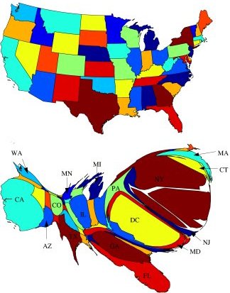
The map was actually featured in the August 2004 issue of Science News magazine and was made by researchers extracting the dateline from about 72,000 wire-service news stories from 1994 to 1998 and modifying a standard map of the Lower 48 US states to show the size of the states in proportion to the frequency of their appearance in those datelines.
StrangeMaps reports:
As any journalist knows, news has to be about people -- they either make it, or are affected by it. No people, no news. It therefore stands to reason that heavily populated areas of the US, like California or the Northeast, generate most of the news stories. But even allowing for population, some locations account for a disproportionately high number of news items.
It is interesting, but not that surprising, that Washington, D.C., and New York generate such a significant portion of the news.
Still, I think there might be some religious news ghosts in this map.
Is Colorado as visible as it is because of Colorado Springs' many evangelical groups? How many mainline church bodies are still headquartered in New York City? Any other ghosts you see in these maps? And what stories are getting missed because they don't take place in highest-population or politically-powerful areas? Is the Bible Belt a non-news zone? The All-American Heartland?
Hmmmm.... What if this map is contrasted with these maps? Or how about (heaven forbid) this one?